
REPORT
Hydrochemistry and environmental isotopes of spring water
and their relation to structure and lithology identified
with remote sensing methods in Wadi Araba, Egypt
Manal Wannous
1
&Barbara Theilen-Willige
2
&Uwe Troeger
1,2
&Marianne Falk
3
&Christian Siebert
4
&Florian Bauer
5
Received: 6 July 2020 /Accepted: 24 March 2021
#The Author(s) 2021
Abstract
Springs located at the historical sites of Wadi Araba (Eastern Desert of Egypt) and emerging from the escarpments of the
Northern and Southern Galala Plateaus were investigated. A combination of methods, including hydrochemistry, stable and
radioisotope composition, and structural analyses based on satellite data, provided information about the structure of the sub-
surface and the derived groundwater flow paths. Satellite images reveal karst features within the northern plateau, e.g. conical
landforms. Karstic caves were documented along both escarpments. Chemical analysis of floodwater from Wadi Araba indicates
higher concentrations of terrestrial salts compared to floodwaters from central and southern parts of the desert. δ
18
Oandδ
2
H
signatures in spring waters resemble those of floodwater and fall on the global meteoric water line, confirming their fast
infiltration with minor influence of evaporation. The aquifer feeding the springs of the Northern Galala Plateau has low retention
and the springs dry out quickly, even after heavy rainfall. Contrastingly,
3
H activities in springs emerging from the Southern
Galala Plateau refer to much slower subsurface passage. With respect to
3
H content (3.8 TU) in recent flood waters, the spring
water at Southern Galala Plateau contains about 40% recently recharged groundwater. However, its largest spring—the St.
Antony spring—discharges water with a radiocarbon age of about 15,000 years. In combination with this spring’sconstant
and high discharge over a period of several months, that age estimate suggests a large reservoir with moderate to high retention.
Keywords Groundwater recharge .Egypt .Stable isotopes .Mean residence time .Lineaments
Introduction
In the Eastern Desert of Egypt, as in most arid regions
worldwide, groundwater is the only noteworthy source
for water supply. Since ancient times, the establishment
of settlements and agricultural areas has relied on that
source, particularly on perennial discharging springs.
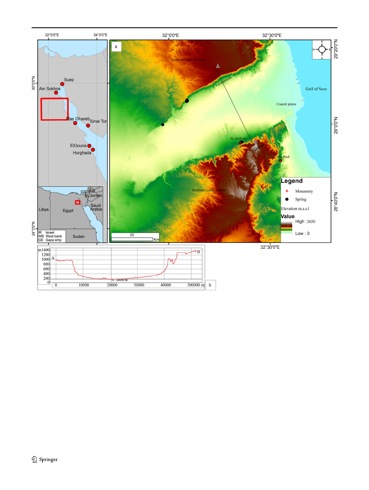
That situation is observable in Wadi Araba, a 110-km
long and about 20-km wide arcuate valley, which is
flanked by the Northern and Southern Galala Plateaus,
and finally opens into the Gulf of Suez in the north-
western part of the Red Sea (Fig. 1). In the Wadi Araba
Valley, groundwater is abstracted from springs and
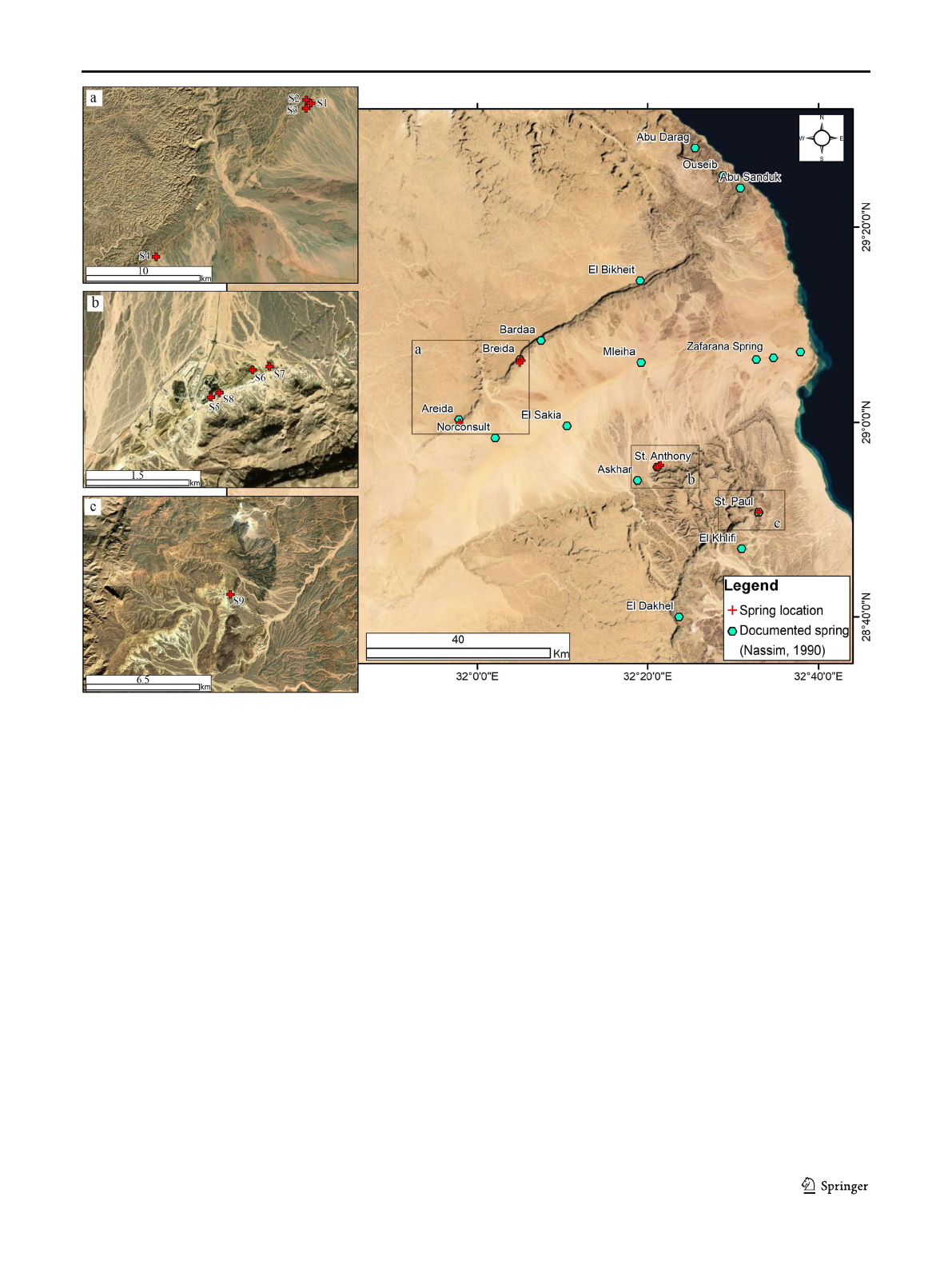
wells scattered over a wide area (Fig. 2). The springs
predominantly originate from the fractured aquifer
forming the Galala Plateaus (El-Sadek et al. 1998).
The northern part, which extends up to the Suez
Governate, contains several thermal springs. Previous
studies investigated their stable isotope composition,
mineralization, the source of the enhanced temperatures
andenergypotential(Sturchioetal.1996; Abouzied
et al. 2020). Nassim (1990) applied aerial images to
analyse lineaments that focus the surface water drain-
age, mapped springs in the region, and classified
*Manal Wannous
manal.wannous@tu-berlin.de
1
Water Engineering Department, Central Institute El Gouna,
Technische Universität Berlin, Acker Str.76, 13355 Berlin, Germany
2
Institute of Applied Geoscience, Technische Universität Berlin,
Ernst-Reuter-Platz 1, 10587 Berlin, Germany
3
Museum of Natural History, Leibniz Institute for Evolution and
Biodiversity Science, Invaliden Str. 43, 10115 Berlin, Germany
4
Department of Catchment Hydrology, Helmholtz Centre for
Environmental Research –UFZ, Theodor-Lieser Str. 4,
06120 Halle, Germany
5
Karlsruher Institute of Technology Campus Nord,
Hermann-von-Helmholtz-Platz 1, 76344 Eggenstein-Leopoldshafen,
Karlsruhe, Germany
https://doi.org/10.1007/s10040-021-02343-x
/ Published online: 4 June 2021
Hydrogeology Journal (2021) 29:2245–2266
groundwater aquifers in Wadi Araba. Following local
knowledge, a number of springs has been documented
along the northern flank of Wadi Araba, usually flowing
insmallpondsusedbysmallcommunities.
Particularly in the Southern Galala Plateau region, produc-
tive springs have been used since ancient times to provide
water for settlements such as the two >1,500-year-old monas-
teries—St. Anthony’s Monastery (SAM), located at the south-
ern flank of Wadi Araba, and St. Paul’s Monastery (SPM),
located some 20 km further SE (Fig. 1). Within the area of
SAM several springs emerge along an 800-m-long lineament
and are intended as emergency source of water supply for 350
residents and for irrigation purposes. Unlike SAM, in the area
of SPM a single spring emerges, intended to serve the same
purpose.
Except for a few quality data of the main springs of
St. Anthony and St. Paul (Nassim 1990), neither re-
charge mechanisms nor discharge dynamics of the
springs that emerge in Wadi Araba and in these histor-
ical sites have been adequately investigated yet.
According to the authors’own measurements, the larg-
est of the SAM springs yields an average discharge of
87 m
3
/day and is flowing all year round, while many of
the small springs along the northern rim of the valley
fall dry. Thus, this study aims at mapping and charac-
terizing the groundwater springs in Wadi Araba, with a
special emphasis on the springs at SAM and SPM. The
evaluation of satellite image data can contribute to: (1)
the detection of fault and fracture zones influencing the
groundwater flow and fluid permeability of rocks, (2)
Fig. 1 aMap indicating the location and morphology of Wadi Araba,
which opens into the Gulf of Suez at the north-western end of the Red
Sea. bTopographic cross section perpendicular to thevalleyaxis.
Episodic floods formed erosional fluvial landforms including large dry
beds and a meandering bed in the central part of Wadi Araba
2246 Hydrogeol J (2021) 29:2245–2266
deriving the youngest fault pattern cutting the most re-
cent sediments as preferable infiltration pathways, (3)
mapping of structural features and lithologic units which
play a role in storing and transporting groundwater, and
(4) monitoring of morpho-dynamic processes influencing
the infiltration of surface water such as sediment flow,
accumulation and erosion.
The chemical analyses of water samples from spring
locations detected in the area clarify which kind of
aquifer is discharging to these springs and what kind
of water/rock interactions take place in the subsurface.
The stable isotope signatures of
18
Oand
2
Hcontribute
to the understanding of (1) climate conditions at which
the water was recharged and (2) whether their isotope
signatures indicate contributions of groundwater from
the Nubian Sandstone aquifer, which springs elsewhere
in the region. The radio isotope analyses of
3
Hand
14
C
were used to calculate the mean resident time of
groundwater in the aquifer, which also allows insight
into whether or not the emerging groundwaters are at
least partially recharged recently by occasional rainfall
or flash floods.
Study area
Climate
The climate in the Eastern Desert of Egypt is arid and gener-
ally characterized by hot summers and moderate winters.
Sporadic and short precipitation events take place in winter
months (between October and April) and their spatial
extension and intensity are extremely variable, e.g. the
event on 27 October 2016 produced more than 100 mm
of precipitation and caused a destructive flash flood in
the town of Ras Ghareb (Saber et al. 2020), while north
(Suez) and central (El Gouna) (Fig. 1), less than 20 mm
of precipitation occurred.
Fig. 2 Map indicating the locations of sampling points in the Wadi Araba area. Inset maps focus on the: aspring group along the northern rim of the
Wadi; bthe Monastery of St. Anthony at the southern rim; cthe Monastery of St. Paul, outside the Wadi on the Southern Galala Plateau
2247Hydrogeol J (2021) 29:2245–2266
The orographic influence of the Galala Plateaus on cloud
distribution in Wadi Araba may lead to rain-bearing cloud
concentration above the Northern and Southern Galala
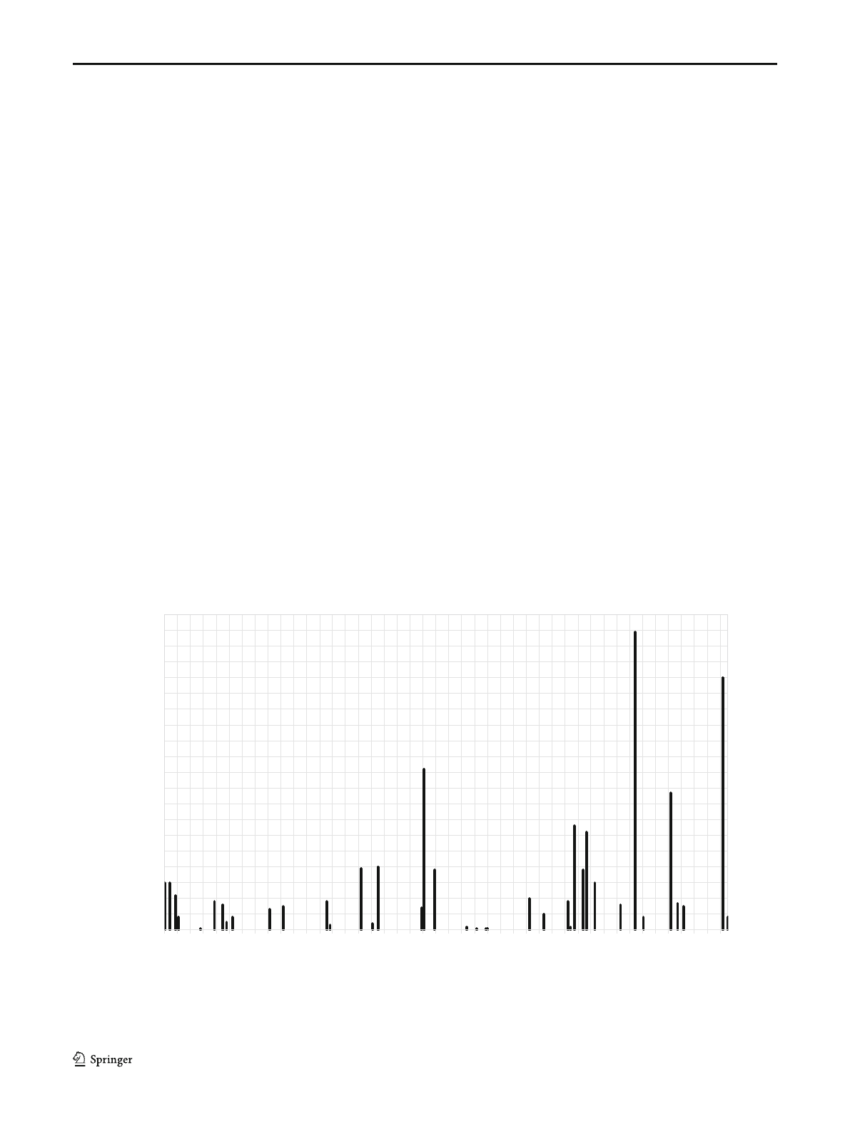
Plateaus. Observations in Suez, which has the closest climate
station to Wadi Araba, show erratic precipitation events with
usually low amounts, less than 6 mm/day, while only a few
events produced more than 10 mm/day (Fig. 3).
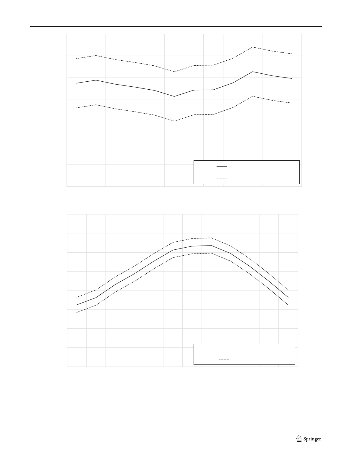
The climate data presented in Fig. 4were obtained from El
Gouna climate station, situated at the Red Sea coastal plain
(27.43 E, 33.66 N). The monthly averages and standard devi-
ations are calculated using the data measured in the period
between March 2014 and January 2019 with a time interval
of 10 min. The range between average ± standard deviation
represents 68% of the data.
The highest temperatures are recorded between June and
August (>30 °C) and the lowest in December/January
(<20 °C). The relative humidity with an annual average of
47% shows a weak seasonal variation with a minimum be-
tween May and August (average 45%) and a maximum be-
tween October and December (average of 50%). Evaporation
data from the region were reported by Awad et al. (1996)with
a maximum annual mean value in June with 10.11 mm/day
and a minimum in December with 6.11 mm/day.
Geomorphology
The geomorphological units of the landscape that are impor-
tant for recharge and precipitation runoff can be differentiated.
The Northern Galala Plateau shows typical conical landforms
related to weathering of limestones and dolomites during more
humid conditions in the past. The uncovered, flat, exposed
fractured carbonate rocks show good properties for recharge.
The Southern Galala Plateau is block-wise intersected by
distinct visible escarpments related to fault zones (Fig. 1). This
area shows traces of an intense erosion such as deeply incised
valleys. Sand and gravel sediments are accumulated in small
depressions. While the northern escarpment is forming an al-
most continuous line, the southern border of the Wadi Araba
basin is characterized by dissected front lines, intersected by
larger N–S-oriented valleys. Along the northern escarpments,
block gliding and rockfall towards the southern direction are a
common feature. This morphology enables recharge in the
hollows and fissures left behind and the steep slopes promote
more surface runoff. The drainage network indicates a rela-
tively flat bedding of the rocks and is probably the result of
parallel tectonic structures.
The interaction between fluvial and tectonic processes is
evident as the development of channels is influenced by sub-
surface structures and geotectonic movements related to plate
tectonic rifting activity in the Gulf of Suez area and northward
movements of the African Plate.
Geology and tectonic
Wadi Araba is a structurally controlled tectonic basin (Fig. 5).
The major force of the structural development in this area was
0
1
2
3
4
5
6
7
8
9
10
11
12
13
14
15
16
17
18
19
20
2006-01-10
2006-04-10
2006-07-10
2006-10-10
2007-01-10
2007-04-10
2007-07-10
2007-10-10
2008-01-10
2008-04-10
2008-07-10
2008-10-10
2009-01-10
2009-04-10
2009-07-10
2009-10-10
2010-01-10
2010-04-10
2010-07-10
2010-10-10
2011-01-10
2011-04-10
2011-07-10
2011-10-10
2012-01-10
2012-04-10
2012-07-10
2012-10-10
2013-01-10
2013-04-10
2013-07-10
2013-10-10
2014-01-10
2014-04-10
2014-07-10
2014-10-10
2015-01-10
2015-04-10
2015-07-10
2015-10-10
2016-01-10
2016-04-10
2016-07-10
2016-10-10
Precipitaon [mm]
Fig. 3 Precipitation depth for the period Jan 2006 to Dec 2016 at Suez climate station (source: National Water Research Center (Egypt), Rainfall data of
the Suez climate station, obtained through personal communications, 2020)
2248 Hydrogeol J (2021) 29:2245–2266
the opening processes of the Red Sea, which started in the
Miocene and continues today (Bosworth and Durocher
2017). The stratigraphy is divided into three major units,
which are related to the evolution of the Red Sea/Gulf of
Suez, i.e. the pre-rift (Pre-Oligocene), syn-rift units (Late
Oligocene–Middle Miocene) and post-rift units (Late
0
10
20
30
40
50
60
70
Jan Feb Mar Apr May Jun Jul Aug Sep Oct Nov Dec
Relative humidity [%]
Average relave humidity
± Standard deviaon
0
5
10
15
20
25
30
35
40
Jan Feb Mar Apr May Jun Jul Aug Sep Oct Nov Dec
Temperature [°C]
Average temperature
± Standard deviaon
Fig. 4 Air temperature and relative humidity records at El Gouna climate station (based on 10 min time series data)
2249Hydrogeol J (2021) 29:2245–2266
Loading more pages...