
Journal of Urban Mobility 2 (2022) 100018
Contents lists available at ScienceDirect
Journal of Urban Mobility
journal homepage: www.elsevier.com/locate/urbmob
What if Air Quality Dictates Road Pricing? Simulation of an Air
Pollution-based Road Charging Scheme
☆
Sandro Rodriguez Garzon
∗
, Marcel Reppenhagen, Marcel Müller
Service-centric Networking, Department of Telecommunication Systems, Technische Universität Berlin, Ernst-Reuter-Platz 7, Berlin 10587, Germany
a r t i c l e i n f o
Keywords:
Dynamic road pricing
Road charging scheme
Air pollution
Air quality
Toll
Traffic simulation
Intelligent transportation system
Smart city
a b s t r a c t
Road tolls serve various purposes, such as to refinance the road infrastructure or to regulate traffic. They are
typically levied for the use of a freeway or the entire road network of a region or country. Toll charges may depend
on the duration of use, the vehicle’s emission class, the time of the day, the distance travelled, or the traffic volume.
The primary objective of a few recent toll system deployments is to internalize externalities with respect to
vehicle-caused air pollution. However, the air quality along the toll roads has so far not been considered to directly
influence road usage prices. This article investigated by simulation the expected monetary expenditure for drivers
and the traffic impact of applying a new distance and air pollution-based charging scheme in the metropolitan
region of Berlin. The road usage charges were determined on a per-trip basis by taking the vehicle’s emission
class, the distance travelled, and the air pollution levels along the route into consideration. The simulation results
indicate that it is beneficial for drivers to avoid areas of high air pollution in order to reduce the trip’s total road
usage charges. The average additional detour distance is thereby short in comparison to the route’s length and
the resulting additional emissions do not increase to the same extent as the number of detours, since detours are
partly even shorter in terms of distance. The explorative analysis gives initial insights into the traffic effects of a
charging scheme in which air pollution dictates road pricing.
Introduction
Urban air pollution originating from the sector of road transport is
known to significantly increase the mortality and morbidity rate of the
affected population ( Künzli et al., 2000 ). For 2018, 18,400 premature
deaths in the U.S. can be attributed to the exposure of traffic-related
air pollution ( Dedoussi, Eastham, Monier & Barrett, 2020 ). The situa-
tion is further complicated by the fact that the global traffic demand
is expected to increase over the next decade ( International Transport
Forum, 2019 ). Successfully applied regulatory measures to fight traffic-
related air pollution include the promotion of environmentally friendly
means of transport ( Xia et al., 2015 ), introduction of traffic control
signal systems ( Wood & Baker ), or the development of more efficient
combustion engines and aftertreatment systems. Nevertheless, the air
pollution in many metropolitan regions remains to exceed many times
the limits recommended by the World Health Organization (2016) or
as set by The European Parliament & the Council of the European
Union (2008) .
In Germany, local authorities of cities particularly affected by
urban air pollution are being forced (due to possible penalties) to
☆The authors declare that they have no known competing financial interests or personal relationships that could have appeared to influence the work reported in
this paper.
∗ Corresponding author.
E-mail address: [email protected] (S. Rodriguez Garzon).
introduce driving bans for vehicles of particular emission classes
( Fensterer et al., 2014 ) or to tighten speed limits on particular road
segments ( Vardoulakis et al., 2018 ). However, depending on how driv-
ing restrictions are implemented, they may have little or no effect on
the urban air pollution ( Davis, 2017 ), worsen the air quality situa-
tion ( Zhang, Lin Lawell & Umanskaya, 2017 ), or even encourage ille-
gal behavior among drivers ( Wang, Xu & Qin, 2014 ). Driving restric-
tions that proved to significantly reduce air pollution are - among oth-
ers - the vehicle pollution charge Ecopass in Milan ( Rotaris, Danielis,
Marcucci & Massiani, 2010 ), the low emission zones (LEZ) in Germany
( Jiang, Boltze, Groer & Scheuvens, 2017 ; Wolff, 2014 ), and the driving
bans in Quito ( Carrillo, Malik & Yoo, 2016 ). The regulatory measures
are different and customized to the local particularities, but the impacts
on the air quality are on a similar order of magnitude. In Milan, the Eu-
ropean vehicle class dictates whether downtown Milan can be entered
for free or by paying a charge that depends upon the vehicle’s emis-
sion class. In Germany, older and high polluting vehicles are generally
prohibited to enter LEZs. In Quito, the last digit of the vehicle plate
determines the day a vehicle is prohibited to enter the restricted area
during peak hours. These and similar driving restrictions are of intrusive
https://doi.org/10.1016/j.urbmob.2022.100018
Received 13 August 2021; Received in revised form 23 February 2022; Accepted 25 February 2022
2667-0917/© 2022 The Author(s). Published by Elsevier Ltd. This is an open access article under the CC BY license ( http://creativecommons.org/licenses/by/4.0/ )

S. Rodriguez Garzon, M. Reppenhagen and M. Müller Journal of Urban Mobility 2 (2022) 100018
nature and are not meant to change over a long period of time. They are
set by municipalities and apply no matter how the urban air pollution
eventually develops at each day and time of the day. Vehicles may be
banned, and drivers be charged although on some days, for example,
the fine dust concentration within the air might turn out to lie far below
a value that is harmful to health.
To be more flexible, a few municipalities and urban areas started to
introduce temporary LEZs that are only active in case high urban air
pollution is predicted or happened in the past days. In Geneva, only ve-
hicles with a state-issued vignette can drive within the LEZ during its
active period. The last day’s level of air pollution determines thereby
the type of restrictions that apply for the vehicles. Despite operating in
a more flexible manner with respect to changing environmental circum-
stances, an activation still needs to be announced a few hours in advance
and an activation is valid throughout the day or at peak hours. These
regulations prevent the system to react spontaneously to an unforeseen
change of the air quality at the day of activation. A further drawback
of currently deployed systems with temporary LEZs is that the extent of
LEZs corresponds to administrative areas or are limited by well recog-
nizable ring-shaped closed transport routes such as city-rings or circular
railways. The range of a fixed LEZ roughly corresponds to the extent
of the urban area that is affected by urban air pollution, but it does not
necessarily represent it accurately on days with exceptional weather and
traffic conditions.
Another principal challenge of applying access-based charging
schemes to reduce air pollution lies in the fact that the costs of using
the road network within an LEZ do not depend upon the real usage. The
more a vehicle drives within an LEZ, the more it pollutes, but the costs
remain constant in Geneva and for all LEZs deployed around the globe.
The Green Activity Zones research project proposed a first-best toll,
namely, to charge a driver of heavy-duty vehicles within a LEZ based
on the emissions measured within the vehicle ( Tretvik, Nordtømme,
Bjerkan & Kummeneje, 2013 ). A similar first-best toll approach sim-
ulates vehicles in Munich that are charged based on their modeled
emissions ( Kickhöfer & Kern, 2015 ; Kickhöfer & Nagel, 2016 ). Both ap-
proaches propose charging schemes that are closely related to distance-
based charging; a charging scheme that has gained more and more popu-
larity in recent years. At toll plazas in France, a driver pays a charge that
depends upon the distance travelled on the freeway. In Germany, drivers
of heavy goods vehicles are obliged to pay a more fine-grained distance-
based toll in case they use the federal highway network ( Broaddus &
Gertz, 2008 ). Instead of toll plazas, an on-board unit –as part of an elec-
tronic toll system - records the exact route so that a fine-granular charge
based on a price per driven kilometer can be applied. But distance-based
charging is currently not applied to deal with urban air pollution de-
spite the proportional correlation between the distance travelled and
the amount of emissions ( Etyemezian et al., 2003 ).
Yet, the technological progresses of the last decade in the fields of
mobile computing, mobile communication, outdoor localization, and
electronic road pricing made it possible - today - to determine the route
of a vehicle by satellite, accurate to the meter, at low cost, and to trans-
mit it reliably to a central authority for control and accounting purposes
( Donath et al., 2009 ). Hence, with the proven technical and economic
feasibilities of distance-based charging schemes, the European Union
plans that until 2023, all European toll systems for heavy good vehi-
cles as well as buses must switch to distance-based charging to improve
fairness and environmental protection
1
.
1 https://www.europarl.europa.eu/news/en/press-room/
20181018IPR16551/reform-of-road-use-charges-to-spur-cleaner-transport-
and-ensure-fairness
At the same time, sensors for measuring air quality have become
more compact, more reliable, and less expensive ( Jova š evi ć-Stojanovi ć
et al., 2015 ). The unit price has even reached a level that allows private
households to measure air quality with their own sensor stations and
share the results with the community ( Muller et al., 2015 ). Coupled with
communication modules, they can now be an integral part of city-wide
dense sensor networks, enabling the urban air quality to be measured in
real time and across the entire city ( Sivaraman, Carrapetta, Hu & Luxan,
2013 ). It is therefore technically possible to develop an intelligent trans-
port system (ITS) that takes the current air quality distribution within
a metropolitan region into account. What role the urban air quality can
play in an ITS depends on the primary objectives, local conditions, and
political decision-makers. If, for example, air pollution hotspots should
be relieved by additional traffic-related emissions, then the spatial and
temporal extent of LEZs could be dynamically determined based on the
time-dependent spatial distribution of the air pollution across an urban
area ( Rodriguez Garzon & Küpper, 2019 ). In other words, the city-wide
air quality dictates the shape, size, and location of temporary LEZs.
In combination with distance-based charging, a driver could then be
charged based on the real distances travelled through dynamically de-
termined LEZs. A temporary LEZ based on high air pollution levels can
thereby be associated with high transit prices per kilometer to make a
transit through an air pollution hotspot less attractive for a polluter than
passing through low polluted area. The charging scheme can also option-
ally be combined with emission class-dependent pricing. The tariff per
kilometer and air pollution level will then - in addition - depend upon
the vehicle’s emission class. A distance and air pollution-based charg-
ing scheme may lead drivers to avoid passing through heavily polluted
LEZs, respectively to stop worsening the situation by an additional pol-
luter, and to switch, instead, to more environmentally friendly means of
transport.
To the best of our knowledge, a highly dynamic road pricing scheme
with spatially and temporally evolving LEZs has not been investigated
yet. To do so, a multitude of research questions arise and need to be
examined with respect to, among many others, the technical feasibility,
usability from the perspective of the road users, the acceptance among
road users, the predictability of returns for the toll operators or collec-
tors, its implications on the mobility behavior, its influence on the urban
air pollution and its socio-economic effects. This article investigates the
implications of such a distance-based and air pollution-aware charging
scheme on the mobility behavior by exemplarily simulating road net-
work usage within the city of Berlin. LEZs are hereby modeled based
on the spatial distribution of the urban air pollution across the city. The
traffic of 10% of the population was simulated for a period of 24 h on
three days with significantly different air pollution characteristics. An
open data-based transport demand model for Berlin was used in con-
junction with real measurements of the particulate matter concentration
taken by privately-owned sensors that were located within the limits of
Berlin. Although needed to finally evaluate the charging scheme with
respect to the objective of improving the overall air quality in an urban
area, its influence on the urban air pollution was not determined because
of a lack of yet to be developed particulate matter dispersion models,
a fine-granular spatiotemporal wind and weather model for the city of
Berlin and a comprehensive list of location-specific polluters other than
motorized vehicles with their individual contributions to the particulate
matter concentrations. However, the results of simulating road usage -
with a hypothetical charging scheme being in place and the air pollution
being modelled by means of real world measurements - are intended to
give first impressions of how parts of the traffic might shift to alter-
native routes, what daily volume and compositions of toll trips can be
expected in Berlin for days with low, medium, and high urban air pol-
lution and how the vehicle-caused emissions might change due to road
users intentionally bypassing LEZs with high transit costs.
2

S. Rodriguez Garzon, M. Reppenhagen and M. Müller Journal of Urban Mobility 2 (2022) 100018
In the following section, recent approaches to set road, parking facil-
ity, and public transport prices based on the predicted or current urban
air pollution are discussed. The core concept of the new air quality and
distance-based charging scheme is then introduced in Section Concept.
In Section Simulation, the simulation setup for Berlin and the simula-
tion results are presented. Assumptions, limitations of the simulations,
and the charging scheme in general are summarized and discussed in
Section Discussion. The article concludes with the major findings, open
research questions, possible applications, and extensions of the charging
scheme.
Related work
The pros and cons of applying dynamic road pricing schemes to
tackle congestion and air pollution have been discussed extensively over
the past decades ( Saharan, Bawa & Kumar, 2020 ; Yang & Huang, 2005 ).
The main property that distinguishes the concept of dynamic road charg-
ing from its static counterparts is the fact that either the road usage fee
as a whole or only a fraction of it may vary depending on the situa-
tional circumstances. Time of the day ( Chen, Xiong, He, Zhu & Zhang,
2016 ), road network load ( Supernak, Steffey & Kaschade, 2003 ), and
car occupancy are the most widespread discussed and considered price-
influencing situation factors in literature or in real world deployments.
Despite the considerable amount of work examining the impact of dif-
ferent charging schemes on the air quality ( Beevers & Carslaw, 2005 ;
Cavallaro, Giaretta & Nocera, 2018 ; Johansson, Burman & Forsberg,
2009 ; Rotaris et al., 2010 ), only a few research articles suggest that the
urban air quality should be considered, directly or indirectly, through
metrological properties, as an additional variable for dynamic road pric-
ing. Coria, Bonilla, Grundström & Pleijel (2015) propose to adjust road
prices dynamically so that the sum of traffic-related emissions do not
exceed the maximum air pollution capacity of an environment (assim-
ilative capacity). Coria et al. (2015) use the wind speed to estimate the
current assimilative capacity and the current traffic load to vary the
prices accordingly, instead of measuring the emissions respectively air
quality. The location-specific correlations between wind speed, air pol-
lution dispersion, and traffic network load are thereby predetermined
based on historical hourly wind speed, air quality, and traffic flow data
for the city of Stockholm. The road usage prices do not reflect the cur-
rent air quality itself but the atmosphere’s ability under the current
wind and traffic conditions to cope with traffic-related air pollution,
without suffering from long-term environmental damage. Further in-
vestigations revealed that pollution peaks indeed can be smoothed if
road charges take the air pollution dispersion into consideration ( Coria
& Zhang, 2017 ). Coria’s approach and the approach taken in this arti-
cle differ in the sense that Coria et al. (2015) examined the impact of
a traffic-, weather and environment-aware charging scheme on the air
quality while this article deals with the impact of an air quality-based
charging scheme on the traffic itself. Despite not dealing with road usage
charges, Reddy, Yedavalli, Mohanty, & Nakhat, 2017 sketched the idea
to link future public transit prices in general to the predicted urban air
pollution. Poorzahedy, Aghababazadeh and Babazadeh (2016) follow a
similar idea and propose to determine the next day’s cordon access fees
and rates for park & ride facilities at public transport hubs based on the
current carbon oxide concentrations and the next day’s weather fore-
casts. The objective is to make public transport pricewise more and pri-
vate vehicle transport less attractive in case high air pollution levels are
forecasted. Although lesser flexible with respect to price determination,
Costabile and Allegrini (2008) present a prototypical ITS that forecasts
air pollution levels for Beijing and automatically imposes driving restric-
tions in case thresholds will likely be exceeded. Today, similar systems
for air quality-dependent driving restrictions are successfully deployed
in Geneva, Budapest, Madrid, and Oslo. But road prices remain to be de-
termined or driving restrictions be imposed based on air quality estima-
tions or forecasts. The estimated or forecasted air quality does not only
deviate from the actual air quality at the time a car ride is charged but
may even not be experienced everywhere in a fixed LEZ or cordon with
the same intensity. Rodriguez Garzon and Küpper (2019) , in contrary,
describe the concept of an air pollution-aware and distance-based charg-
ing scheme in which the price per kilometer depends upon the urban
air pollution that is measured along the route. It incorporates distance-
based charging to fairly price the environmental damage caused by a
single car ride and it adjusts the fees dynamically to the urban air pollu-
tion to make the worsening of an already critical air pollution situation
more costly than the worsening of a non-critical situation. This article
adopts this new and highly dynamic concept of road pricing and applies
it in a customized way hypothetically to the city of Berlin.
Air pollution-aware charging
The road charging concept under investigation comprises of
distance-based charging and air pollution and emission class-dependent
road usage prices. The principal idea of the concept is that the road us-
age price per kilometer increases as urban air pollution levels rise along
the way, no matter, whether the air pollution originates primarily from
traffic or other sources such as wood burning or the industry sector. The
concept’s main objective is to reduce the urban air pollution at pollu-
tion hotspots by encouraging or incentivizing the drivers to reconsider
the transport mode and/or the route decision. By changing their route,
drivers are supposed to spread the emissions more evenly across the city.
The charging happens independently of the traffic load or assimilative
capacity of the environment. Even if the environment might be able to
cope with a very high air pollution without suffering long term damages,
prices per kilometer will be high if air pollutions levels are high. This
does not mean that the proposed charging scheme is not able to take the
assimilative capacity or traffic load into consideration. However, in this
article, it will solely be investigated in an isolated and unbiased manner
to simplify the interpretation of the results. In further studies and pos-
sible extensions, the assimilative capacity could, for example, be used
to support the tariff specification process while the variable traffic load
can serve as another dynamic variable for the price calculation.
In general, air pollution caused by traffic is made up of different
components. Gas emissions in form of nitrogen dioxide, carbon monox-
ide, and sulfur dioxide or particulate matter are only some of the well-
known waste products of burning fossil fuel in combustion engines
( Berkowicz, Winther & Ketzel, 2006 ). The urban air pollution is usu-
ally given in the form of an air quality index (AQI) ( Cheng et al., 2007 ).
An AQI groups together different pollutants and maps the combination
of pollutant concentrations to a few pollution levels, e.g., low, medium,
and high. Instead of progressively linking the road usage price directly
to the individual concentrations of pollutants in the air, in the proposed
concept, the road usage price at a location depends primarily on the
location-specific and discretized AQI level. A current AQI level can ei-
ther be determined for a whole toll area as applied in Geneva for the air
pollution-dependent LEZ, or at each position individually. An individ-
ual AQI level per arbitrary position, however, is only possible if the air
quality can be determined with high accuracy, at any road within the
toll area. Hence, the air quality sensor density across the toll area needs
to be sufficiently high to be able to accurately interpolate air pollution
levels without significant deviations from the real exposure. Given these
requirements are fulfilled, then, at each point in time, a toll area can be
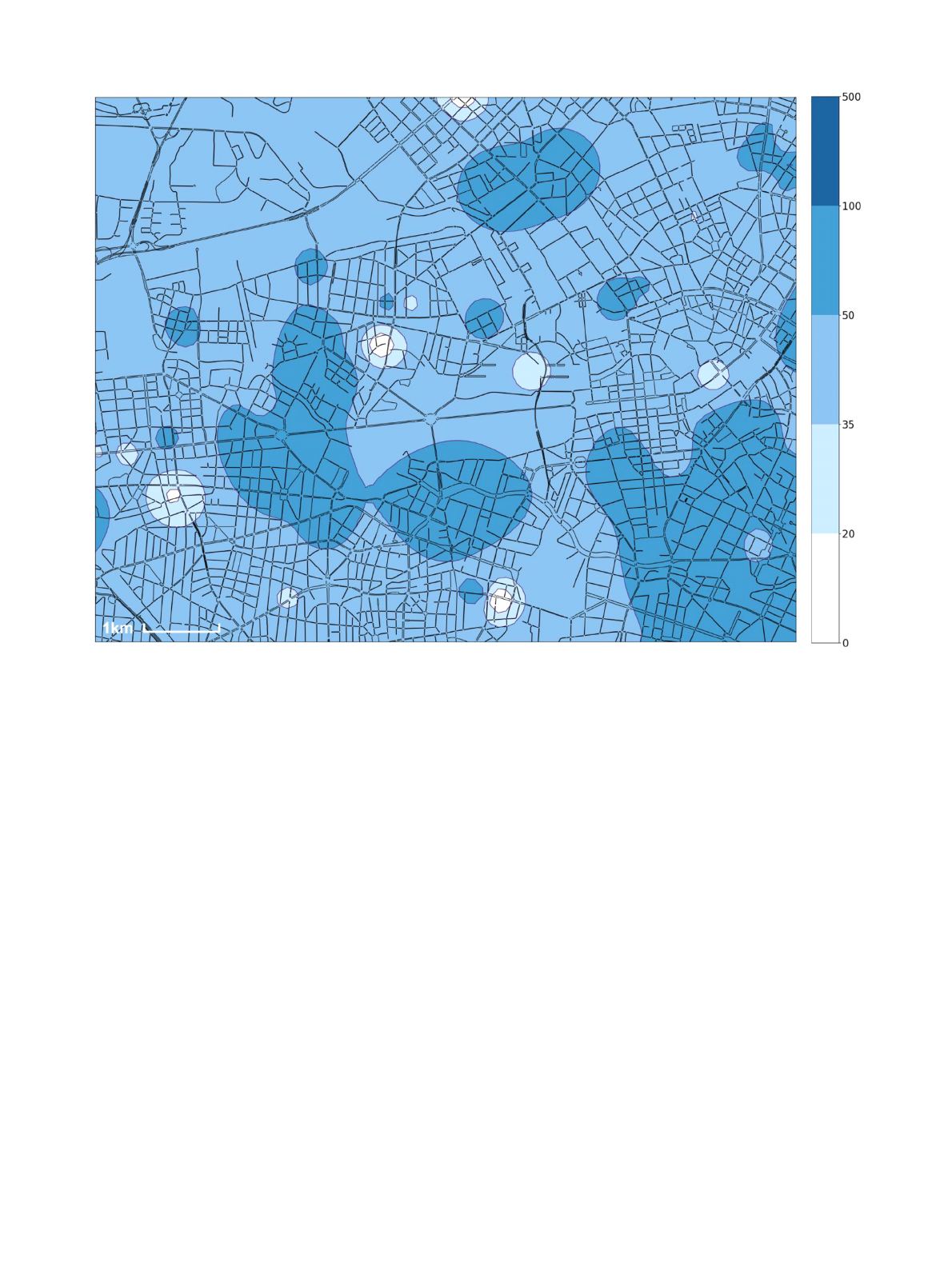
spatially segmented into coherent zones with the same AQI level. Fig. 1
illustrates exemplarily the particulate matter-driven AQI zones as deter-
mined for the 24th of January 2020 at 9:00 AM in the downtown of
Berlin. The charging scheme interprets each blueish AQI zone as a tem-
porary LEZ with a fixed price per kilometer as applied throughout the
whole LEZ. AQI zones might contain holes in which different AQI levels
are measured or interpolated. The resulting temporary LEZs may there-
fore contain smaller LEZs that are associated with different road usage
prices. Since temporary LEZs are not statically defined by a human in-
stance but being processed based on the urban air pollution distribution,
3
S. Rodriguez Garzon, M. Reppenhagen and M. Müller Journal of Urban Mobility 2 (2022) 100018
Fig. 1. Particulate matter-driven AQI zones for downtown Berlin on the 24th of January 2020 at 9:00 AM, given in μg/m
3
.
city, district limits, or distinctive infrastructures, such as city highways,
do not serve as delimiters for the temporary LEZs
As the measured air quality at a given position can vary considerably
within a short period of time, e.g., due to a single gust of wind, so can the
extent of the temporary LEZs vary significantly or the LEZs even “move ”
or disappear. To deal with the dynamics of urban air pollution and the
operational implications on an air pollution-based charging scheme, two
distinct measures are taken. To cope with strong short-term fluctuations
at a sensor, the air pollution is measured over a certain period and the
sensor readings being averaged using the inverse distance weighting
method. The values measured last are thereby given a higher weight to
take trends into account. The resulting LEZs thus reflect the geographical
distribution of air pollution more accurately, but still change over time.
If temporary LEZs were determined in very short time intervals under
adverse weather conditions, it would be difficult, if not impossible, to
predict the road usage charges for a longer car ride. However, according
to the Smeed Report ( Ministry of Transport, Great Britain, 1964 ), price
stability and ascertainability by the road user are crucial factors for the
success or acceptance of a road charging scheme. To make the price
of a journey more predictable, temporary LEZs are active for a certain
amount of time by freezing the measurement results (AQI zones) for an
activation period. For example, the air quality is measured from 1:45 PM
until 2:00 PM and the resulting temporary LEZs are active from 2:00 PM
until 3:00 PM. The longer the activation period is, the more predictable
are road charges for a car ride. On the other hand, towards the end of
an activation period, LEZs may tend to inappropriately represent the air
pollution distribution because of changing weather conditions. Hence,
there is always a trade-off between the accuracy of the air pollution dis-
tribution representation by means of temporary LEZs and the length of
the activation period. To find the right balance, local conditions such
as average driving time, driver acceptance, and the local dynamics of
weather conditions must be considered.
In the proposed concept, the road usage price is not only linked to
the temporary LEZ a vehicle is driving through but also to the vehicle’s
emission class. As it is common in today‘s ITSs and toll system installa-
tions, the higher the emission of a vehicle is, the higher is the base price
per kilometer. The total road usage charge 𝑐
𝑡𝑜𝑡𝑎𝑙
of a car ride results from
the LEZ transits charges for all passed AQI zones 1 to 𝑧 :
𝑐
𝑡𝑜𝑡𝑎𝑙
=
𝑧
∑
𝑖 =1
𝑑
𝑖
∗ 𝑝
(𝑙
𝑖
, 𝑒
)
An LEZ transit charge is determined by multiplying the distance trav-
elled within the LEZ 𝑑
𝑖
with the price p() per emission class 𝑒 and AQI
level 𝑙
𝑖
of the AQI zone i . Thus, road usage charges are determined in-
dividually per trip, depending on the distance a vehicle traveled across
air polluted zones. In contrast to LEZs in Germany and Switzerland, all
vehicle types are permitted to enter temporary LEZs with arbitrary AQI
levels.
For an operational deployment of the proposed charging scheme
within an ITS, vehicles must be accurately locatable in a continuous
fashion and air pollution must be directly measurable by connected sen-
sors on a fine granular manner in a city-wide scale and accurately in-
terpolatable at positions where no air pollution sensors are located. In
addition, road users should be able to examine expected road usage fees
prior to a trip and be notified of sudden price changes via a sort of con-
nected mobile device such as a smartphone or on-board unit. But the
investigations conducted in this article assume the dynamic charging
scheme to be hypothetically applied to road network users independent
4

S. Rodriguez Garzon, M. Reppenhagen and M. Müller Journal of Urban Mobility 2 (2022) 100018
of any concrete technical implementation of it. The reader is referred
to the article “Pay-Per-Pollution: Towards an Air Pollution-Aware Toll
System for Smart Cities ”( Rodriguez Garzon & Küpper, 2019 ) for a more
detailed discussion about the requirements of such a charging scheme
like price predictability, the corresponding challenges like user accep-
tance and its technical feasibility.
Simulations
The traffic in Berlin was simulated with the air pollution-aware
charging scheme being applied in order to determine the daily volume
of transit journeys through AQI zones exemplarily on days with varying
levels of urban air pollution. This makes it not only possible to estimate
future revenues for the toll collector and local authorities, but also to
examine the impact of the road charging scheme on the traffic and the
traffic-induced emissions. The research questions investigated in this ar-
ticle are the following:
■RQ1 : What is the overall toll volume in terms of expected AQI zone
transits per day?
■RQ2 : How often are tariff changes experienced by the drivers during
a trip?
■RQ3 : To what extent are AQI zones bypassed?
■RQ4 : What are the characteristics of the detours?
■RQ5 : To what extent are emissions from motorized vehicles chang-
ing?
■RQ6 : What is the impact of detours on the traffic distribution?
Whether the proposed air pollution-aware charging scheme reduces
the overall air pollution or, at least, helps to evenly distribute the emis-
sions across the urban area are not investigated and remain as open
questions for further research.
The greater area of Berlin was chosen as the hypothetical toll area
because Berlin has sufficient air quality sensors distributed across the
city area, only a minor amount of deep urban canyons due to mostly
low multi-story or single-family buildings, flat terrain, and city-wide ho-
mogenous weather conditions. In addition, there is an open data-based
transport demand model for Berlin publicly available ( Ziemke, Kad-
doura & Nagel, 2019 ). The synthesized transport demand model was
developed by Ziemke et al. (2019) using different open data sources
such as, e.g., a nation-wide census of Germany, commuter statistics,
and local traffic counts. A comparison of the model’s results with those
of two independent travel surveys shows that it realistically emulates
transport demand in and around Berlin. The reader is referred to the
work of Ziemke et al. (2019) for more details about the synthetization
and validation of the transport demand model. The investigations of the
proposed charging scheme can then be conducted with urban air pol-
lution and transport demand models that represent or, in case of the
transport demand model, well approximate real-world conditions.
In the following, the experimental setup of the simulations is de-
scribed, including the general assumptions and configurations. After-
wards, the simulation results are presented in detail.
Setup
Berlin has an urban area of approx. 891.68 km
2
, a population den-
sity of approx. 4115 inhabitants per km
2 and a road network of ap-
prox. 5437 km length. Berlin is in a moderate climate zone with prevail-
ing continental southwest winds and maritime northwest winds. Due to
lesser traffic, flat terrain, weather conditions, and only a small manufac-
turing industry within the city limits, the air pollution is not as severe
as in cities with a similar population of about 3.7 million. Neverthe-
less, on 27 days in 2018, a state-operated measuring station in Berlin
recorded an exceedance of the limits for fine dust pollution with PM
10
2
2 https://www.berlin.de/sen/uvk/presse/pressemitteilungen/2019/
pressemitteilung.775788.php
Table 1
Particulate matter-driven air quality index.
PM
10
(μg/m
3
) 0 - 20 20.1 - 35 35.1 - 50 50.1 - 100 > 100
AQI level 0 1 2 3 4
Air quality very good good moderate poor very poor
(particulate matter with a diameter of 10 𝜇m or less). However, 6 of
the 16 state-operated and connected air quality measuring stations are
located especially at major roads and 5 out of 16 are located at the
outskirts or forests where a particularly high respectively low air pollu-
tion is expected
3
. Measurements taken in urban background roads may
significantly vary from the air pollution levels measured along major
roads ( Boogaard et al., 2011 ). Hence, measurement stations along ma-
jor roads are only of limited help to properly interpolate air pollution
levels in their surroundings due to their strong bias towards high air
pollution. Only a “well-placed site ” allows to estimate proper air qual-
ity values for the surroundings ( Williamsand et al., 2014 ). Privately-
owned and operated air pollution sensors are installed at windows, on
balconies, walls, or roof-top terraces and are arbitrarily located across
a metropolitan region. Community-driven air quality measurement ini-
tiatives, in general, gained popularity over the last decade, leading to
multiple deployments worldwide. In Berlin and similar metropolitan re-
gions, the amount of privately-owned and operated sensors, as used for
crowdsourcing air quality data, exceeds the number of state-operated
sensor installations many times. During the first half of 2020, between
375 and 430 private air pollution sensors within the limits of Berlin
contributed their sensor readings to the citizen science initiatives Luft-
daten.info
4 ( Blon, 2017 ) and OpenSenseMap
5
. Fig. 2 shows the loca-
tion of Luftdaten.info- and OpenSenseMap-connected sensors across the
metropolitan region of Berlin. Nine most probably faulty sensors were
not considered because they delivered constantly air quality values that
reached far beyond the ones of their closest neighboring sensors. Au-
tomatic outlier detection and filtering was deployed as well. The local
sensor density correlates in Berlin roughly with the population density
( Arandelovic & Bogunovich, 2014 ). The low sensor density in the north-
west, mid-west, south-west, and south-west is attributed to a low pop-
ulation density because lakes and forests predominate the respective
outskirts of Berlin.
Every two to three minutes, the air quality is measured by the
privately-owned and operated sensors and the readings being trans-
mitted to a central unit managed by the initiatives. Based on these
crowdsourced and publicly available measurements in Q1 and Q2 of
2020, three days were selected to adequately represent days with low,
medium, and high PM
10
concentrations in Berlin. Fig. 3 visualizes the
AQI zones for Berlin at each of the selected days at different day times.
The discrete mapping of PM
10
concentrations to AQI levels is based on
the air quality index provided by the Federal Environment Agency in
Germany
6
. Table 1 shows the mapping from PM
10
values to AQI levels
and air qualities as used throughout this article. AQI level 0 is consid-
ered as harmless to health and a transit through an AQI zone of level
0 will therefore not be charged. At the 25.03.2020 (low average PM
10
concentration), southeast winds with wind speeds of about 7–17 km/h
were measured throughout the day. At the 11.06.2020 (medium av-
erage PM
10
concentration), northeast winds of about 6–8 km/h were
registered while on the 24.01.2020 (high average PM
10
concentration),
north and east winds of about 2–14 km/h were measured. In general,
wind speeds were low which in turn increased the accuracy of inter-
polations as described in the next paragraph. In this study, gases such
3 https://www.berlin.de/senuvk/umwelt/luftqualitaet/de/messnetz/blume.shtml
4 https://www.luftdaten.info
5 https://www.opensensemap.org
6 https://www.umweltbundesamt.de/berechnungsgrundlagen-
luftqualitaetsindex
5
Loading more pages...