
OVERVIEW
Merging patterns and processes of diffuse pollution
in urban watersheds: A connectivity assessment
Eva Paton | Nasrin Haacke
Ecohydrology, Institute of Ecology, TU
Berlin, Berlin, Germany
Correspondence
Eva Paton, Ecohydrology, Institute of
Ecology, TU Berlin, Berlin, Germany.
Email: [email protected]
Funding information
Deutsche Forschungsgemeinschaft
Edited by: Stuart N. Lane, Editor-in-
Chief
Abstract
Urban diffuse pollution affects water resources as much as its rural counterpart
does; however, it is considerably less studied. The full complexity of the urban
landscape needs to be addressed to apprehend the diversity of surface layouts and
covers, multiple pollution sources, and the diverse changes caused by different
types of drainage systems. In this article, crucial patterns of pollution source areas
are categorized, and current knowledge on their temporal and spatial variations
are collated. Urban alterations of transport processes that enhance, delay, or
inhibit diffuse pollution transport from source areas through the urban watershed
are detailed. Current knowledge regarding diffuse pollution patterns and processes
is conceptually merged by the simultaneous assessment of urban structural and
functional connectivity relevant for pollutant transfer. Applying a more holistic
approach is considered a prerequisite for identifying critical source areas of diffuse
pollution within complex urban catchments, to minimize the transfer of particular
harmful pollutants and to enhance future management of urban waters.
This article is categorized under:
Science of Water > Water Quality
Engineering Water > Planning Water
KEYWORDS
connectivity, urban pollution, sustainable urban drainage design, critical source area
1|INTRODUCTION
Diffuse pollution of urban water resources remains a serious global environmental problem, despite considerable efforts under-
takeninthepast.Urbandiffusepollutioncomprisesfluxesofdissolved or particulate pollutants that enter urban water
resources through precipitation, infiltration, or runoff processes from streets, yards, roofs, commercial areas, and heavily modi-
fied urban soils. Such pollutants have detrimental impacts on the quality of both surface water and groundwater. Diffuse pollu-
tion must be distinguished from urban point-source pollution, where contaminants enter the environment from easily identified
sites, such as the outlet of an industrial or sewage treatment plant (Fletcher, Andrieu, & Hamel, 2013). In contrast, diffuse pollu-
tion, sometimes also called nonpoint pollution, originates from widespread activities with no definitive discrete source.
In the past, a ubiquitous drainage and sewage system in industrialized cities was believed to be the most practical
solution to the pollution problem stemming from urban stormwater and sewage (Chocat et al., 2007). However, the
Received: 22 July 2020 Revised: 15 March 2021 Accepted: 16 March 2021
DOI: 10.1002/wat2.1525
This is an open access article under the terms of the Creative Commons Attribution-NonCommercial License, which permits use, distribution and reproduction in any
medium, provided the original work is properly cited and is not used for commercial purposes.
© 2021 The Authors. WIREs Water published by Wiley Periodicals LLC.
WIREs Water. 2021;8:e1525. wires.wiley.com/water 1of19
https://doi.org/10.1002/wat2.1525
deteriorating quality of urban waters has continuously raised concerns (Makepeace, Smith, & Stanley, 1995). At the
same time, regulations such as the EU water framework directive demand good ecological status for urban waters.
Common pollutants in urban waters include trace organics, heavy metals, nutrients, contaminated sediments, petro-
leum by-products, pesticides, and pathogens (see, e.g., reviews by Miller and Hutchins (2017) for urban rivers and
Jurado, Vazquez-Sune, & Carrer, 2012 or Howard & Gerber, 2018 for groundwater). Some of the toxicants cause lethal
and sub-lethal effects on aquatic organisms; O
2
deficit and eutrophication occur frequently due to elevated organic mat-
ter (Wenger et al., 2009). Hence, a sustainable management of urban waters has not yet been achieved.
A current research frontier is the analysis of how pollutants are retained within the complex landscapes of cities and
released laterally toward rivers and vertically toward groundwater during high-intensity storm events. The identification of
source areas and the resulting mobilization of pollutants during storm events from urban surfaces continue to be significant
challenges in the research on urban water pollution (Fletcher et al., 2013; Pitt, Bannermann, Clark, & Williamson, 2004a,
2004b; Wang et al., 2017). Addressing this problem is not simple because the urban contribution to diffuse pollution varies
widely as a complex function of surface cover and sealing, connection degree and type of drainage systems, soil types and
their urban transformations, climate, topography, and management approaches, such as the frequency of street and snow
cleaning routines (Duncan, 1995; Göbel, Dierkes, & Coldewey, 2007). The poorly defined and poorly identified spatial layout
of pollutant sources in urban landscapes makes the identification and control of diffuse pollution particularly difficult.
Urban diffuse pollution is directly linked to the excessive alterations of the hydrological regime due to urbanization,
that is, high levels of impermeable surface areas, altered river systems, and up to 100% of the city area connected to sew-
age and drainage networks (however, a significant smaller percentage is achieved in most cities of the global south as
quantified by Corcoran et al., 2010). Impacts of the implementation of drainage systems are higher runoff and pollutant
peaks, less recharge to the groundwater (i.e., much more lateral than vertical water distributions), and decreased low-
flow conditions (Cristiano, ten Veldhuis, van de Giesen, 2017; Fletcher et al., 2013). Currently, there is a trend of mov-
ing away from traditional, hard engineering, and centralized urban drainage solutions toward a more natural drainage
approach to reduce the peakedness of drainage and sewer overflow. This step-change involves an increasing extent of
decentralized and natural measures for rainwater management (Golden & Hoghooghi, 2018) known under several
names, such as sustainable urban drainage (SUD) measures, nature-based solutions, or green infrastructure (see
Fletcher et al., 2015 for a full review of terminologies). This trend results in a paradigm shift from wanting to remove
urban water rapidly toward wanting to keep it in the city for as long as possible.
For both centralized and decentralized drainage approaches, we have incomplete knowledge regarding the precise
source of the pollutants, if and when they accumulate, and their pathways toward urban rivers or groundwater
(Lundy & Wade, 2013). The transition from a traditional to a decentralized urban drainage is ultimately a change in the
connectivity of vertical and horizontal water fluxes. This transition relates to a change from artificially increased lateral
and heavily reduced vertical water fluxes in the centralized drainage approach to considerably more vertical fluxes
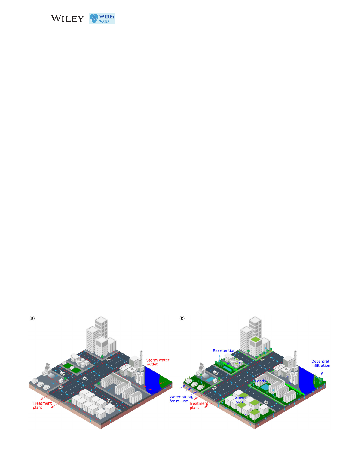
down (groundwater) and up (evapotranspiration) in decentralized approaches (Golden & Hoghooghi, 2018). Figure 1
depicts the differences in the main flow directions between the two systems: (a) the centralized systems with mostly
FIGURE 1 (a) Centralized versus (b) decentralized approaches for urban drainage (red line: drainage network, red arrows: storm-water
outlet points into rivers, blue arrows: street runoff, infiltration, and evapotranspiration)
2of19 PATON AND HAACKE

horizontal flow patterns (blue lines indicate the street runoff, red lines represent the drainage and sewage network, and
the red arrows locate flows toward the treatment plant or toward storm-water outlet points (also called combined sewer
overflows from which excess waste and drainage water is discharged directly into the rivers during heavy rainfall);
(b) the decentralized systems with a significant increase in vertical flow patterns toward groundwater or the atmosphere
(blue arrows), retention and storage of water in different storage units, and no storm-water outlet points into the river.
We argue that the handling of diffuse pollution should address the prevalent and changing nature of the connectiv-
ity of water and pollutant flows in either drainage system. The concept of hydrological connectivity has proven to be
very useful for understanding diffuse pollution in rural catchments (such as studies on nutrient export causing eutro-
phication, e.g., Heathwaite, Quinn, & Hewett, 2005, Dupas et al., 2015, Gonzalez-Sanchis et al., 2015, Stachelek &
Soranno, 2019), but has not yet been applied to urban settings. We use the connectivity definition by Turnbull
et al. (2018), who define hydrological and pollutant connectivity as the degree to which a system facilitates the transfer
of water and pollutants through itself, through coupling relationships between its components. In this review, we take
a holistic perspective on urban diffuse water pollution dynamics to address the full complexity of associated urban con-
nectivity, patterns and processes including urban surface heterogeneity, meteorological, hydrological, and soil variabil-
ity, drainage systems, and decentralized drainage measures. Process-descriptions of (dis)connectivity of water and
pollutant movement throughout urban catchments will facilitate the identification of critical source areas of the city-
scape, where significant amounts of pollution that end up in urban waters are generated (Brierley, Fryirs, & Jain, 2006).
Consequently, pollution control of the critical source areas is likely to be more cost-effective than attempts to control
pollution across the cityscape (Steuer, Selbig, Hornewer, & Prey, 1997).
We presume that only a better understanding of the interlinked dynamics of source areas and pathways will enable
better management of urban water resources. In this study, we assemble the current knowledge to achieve this goal.
(a) We classify crucial patterns of pollution source areas and variables that dominate or influence urban diffuse pollu-
tion. (b) We then discuss the urban alterations of transport processes that enhance, delay, or inhibit diffuse pollution
transport from source areas through the urban watershed. (c) Finally, we examine how we can theoretically merge
patterns and processes of urban diffuse pollution within a hydrological and pollutant connectivity framework and
practically enhance future management of urban waters.
2|SPATIAL AND TEMPORAL PATTERNS OF DIFFUSE POLLUTION ON
URBAN SURFACES
2.1 |Spatial patterns of diffuse pollution
The quantification of diffuse pollution patterns involves two methodologies: an adapted end-of-pipe field approach and
the source area sampling.
Adapting an end-of-pipe field approach, diffuse pollution originating from sealed surfaces is frequently quantified in
stormwater at sampling points inside the drainage systems, at sewer overflow points, or directly in urban rivers. Recent stud-
ies by Eriksson et al. (2007), Pal, He, Jekel, Reinhard, and Gin (2014), and Corada-Fernández et al. (2017), for example,
quantified emerging organic contaminants such as surfactants, algal toxins, or priority substances in urban rivers or aquifers.
However, these studies do not relate contamination directly to potential source areas. Thus, in theseexamples,diffusepollu-
tion is sampled applying a method that is more applicable for point source pollution using storm-water outlets as collectors
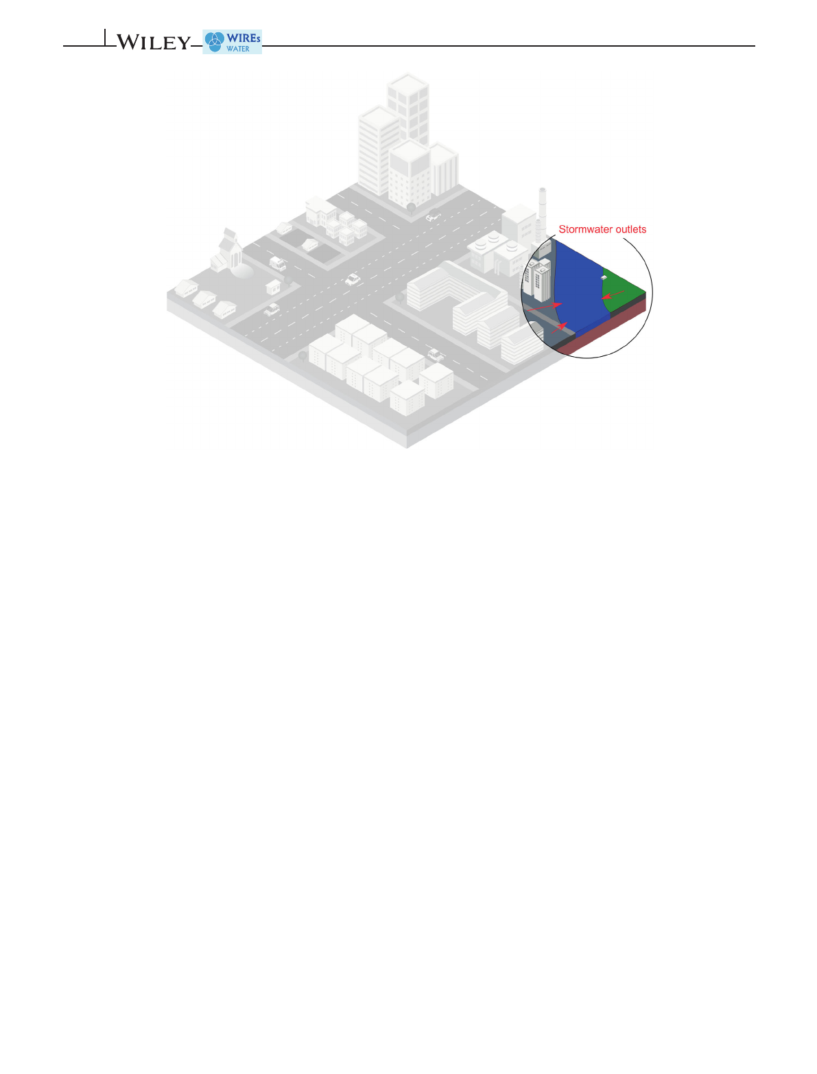
of pollution originating from various sources. Figure 2 illustrates this “simplified”end-of-pipe perspective by showing the
efforts of quantifying pollution loads from storm-water outlets or inside water-bodies (highlighted circle) but ignoring the
hidden complexity “upstream”of these outlet points (depicted as a gray shaded cityscape).
The source area sampling examines the degree of pollution directly on urban surfaces by quantifying either the
potentially available pollution load or pollutant concentration in sheet flow running on these surfaces (Figure 3). The
reviews by Duncan (1995), Pitt et al. (2004a, 2004b), and Göbel, Dierkes, and Coldewey (2007) compiled literature on a
wide range of different surface types and parameters that showed the highest contribution to diffuse pollution. Sampled
source area pollution included heavy metals and organic salts on roads, sidewalks, car parks and different roof surfaces,
organic litter from urban green (parks, yards, and street trees) and contaminants due to atmospheric deposition. These
studies demonstrate the vast extent of current knowledge on contaminant concentrations and their potential sources.
However, a coherent categorization of all different source types, their intrinsic spatial patterns, and temporal
dynamics have not yet been performed consistently. We propose to group urban patterns that dominate or influence
PATON AND HAACKE 3of19
diffuse pollution into four categories: (a) pollution patterns that accumulate or build up on the surface, (b) static pollu-
tion patterns (considered relatively stationary from years to decades), (c) management patterns that influence pollution
structure, and (d) hydrological response factors that influence the generation of overland flow or infiltration toward
groundwater (Figure 3). Current knowledge on pollution types, their spatial compositions, and temporal dynamics of
the four categories are discussed in the following paragraphs by identifying existing detailed review studies or gaps in
the literature.
Pollution patterns that accumulate
a. Dry and wet atmospheric deposition result in the vertical transfer of a wide range of pollutants in dissolved and par-
ticulate form from the atmosphere to all urban surfaces (streets, buildings, and plant surfaces). These pollutants
include nitrogen, sulfur, and phosphorus deposition (see, e.g., Vet et al., 2014 for a recent global assessment), heavy
metals such as Pb, Zn, Cu, Cd, and Cr (Göbel et al., 2007), Hg (recent studies, e.g., Lynam et al., 2016), and polycy-
clic aromatic hydrocarbons (PAHs, e.g., Kim & Young, 2009). Sources are typically related to major anthropogenic
air pollution due to power stations, industries, traffic fumes, and heating.
Deposition patterns show strong spatial variations within cities with generally more pollution in central and indus-
trial areas and thus depend considerably on city size, structure, climate, and traffic volume (Göbel et al., 2007).
Temporal variations include seasonal variations due to different annual rainfall distributions and different intensi-
ties of air pollution from power stations and heating systems in the winter season (Pitt et al., 2004b). Long-term pat-
terns are detected for sulfur, whose emissions declined significantly in line with reduction policies over the last two
decades (Vet et al., 2014). Other long-term variations have resulted from a significant increase in pollution loads in
rapidly growing cities over the last several decades, specifically for Hg, as assessed by Wu et al. (2018) for Beijing.
b. Street pollution due to cars originate from automobile emissions and inadequate automotive maintenance
(Campbell, D'Arcy, Frost, Novotny, & Sansom, 2004; Wada, Takei, Sato, & Tsuno, 2015). Pollutants include airborne
heavy metal particulates, such as Pb attributed to emissions from motor vehicle exhausts and heavy metals, PAHs,
and microplastics originating from mechanical operation wear, such as road surface abrasion, tire abrasion, and
brake pad abrasion (Barjenbruch, 2018; Crabtree, Dempsey, Johnson, & Whitehead, 2008; Göbel et al., 2007; Pitt
et al. 2004b; Poudyal, Chochrane, & Bell-Mendoza, 2016). Drip losses lead to local contamination with mineral oil
hydrocarbons (Göbel et al., 2007). Tire wear has been identified as a significant source of Zn (Pitt et al., 2004a).
FIGURE 2 End-of-pipe sampling of diffuse pollution at storm-water outlets in urban catchment
4of19 PATON AND HAACKE
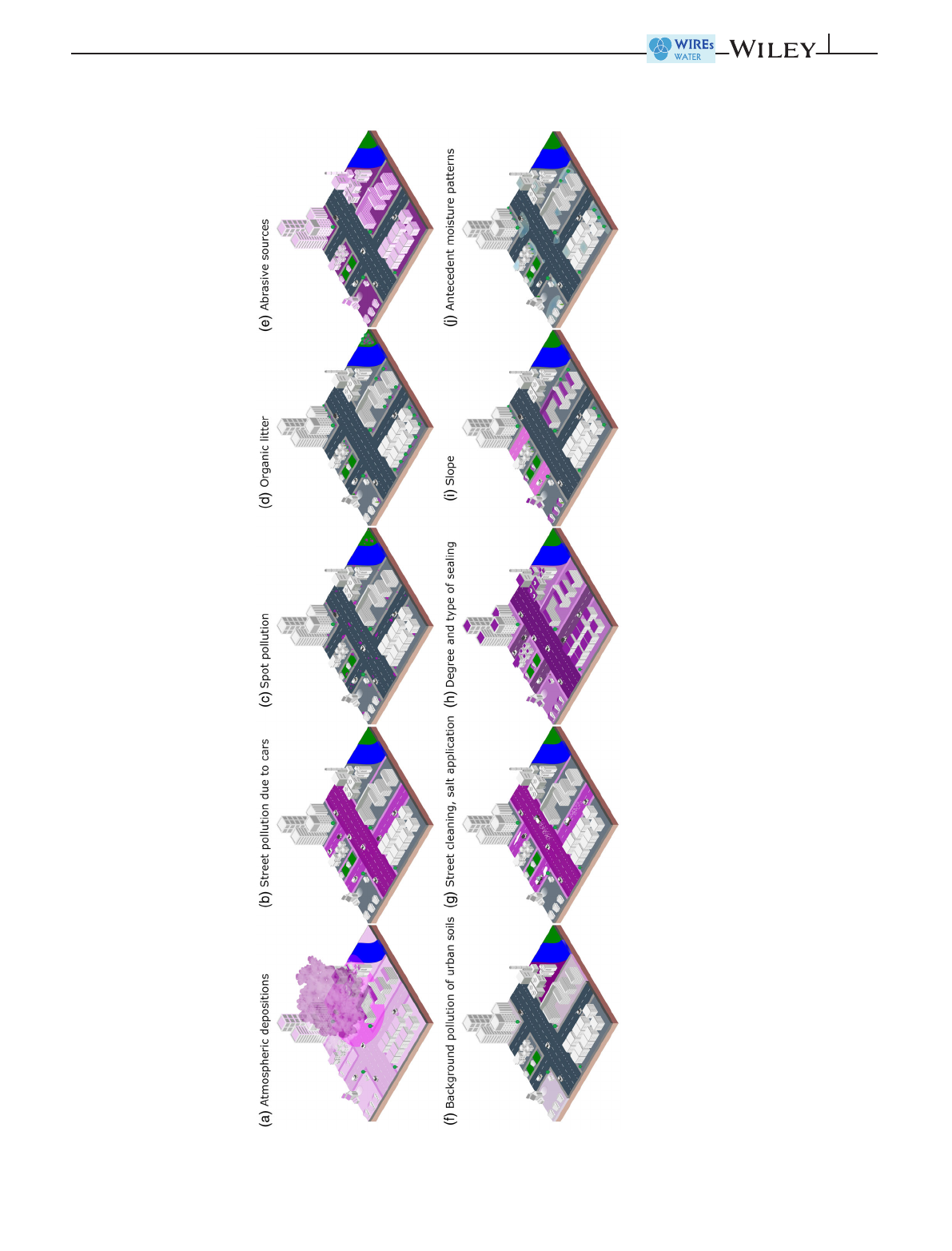
FIGURE 3 Spatial source area patterns that dominate or influence urban diffuse pollution: (a–d) pollution patterns that accumulate, (e–f) static pollution patterns, (g) management
routines affecting pollution patterns, and (h–j) hydrologically relevant patterns—(h) degree and type of sealing, (i) antecedent moisture pattern, and (j) slope. Pink shading shows the extent
and magnitude of the different pollution patterns (except it depicts the degree of sealing in h) and the slope magnitude in (i). Gray shading in (j) shows the magnitude of soil moisture
PATON AND HAACKE 5of19
Loading more pages...